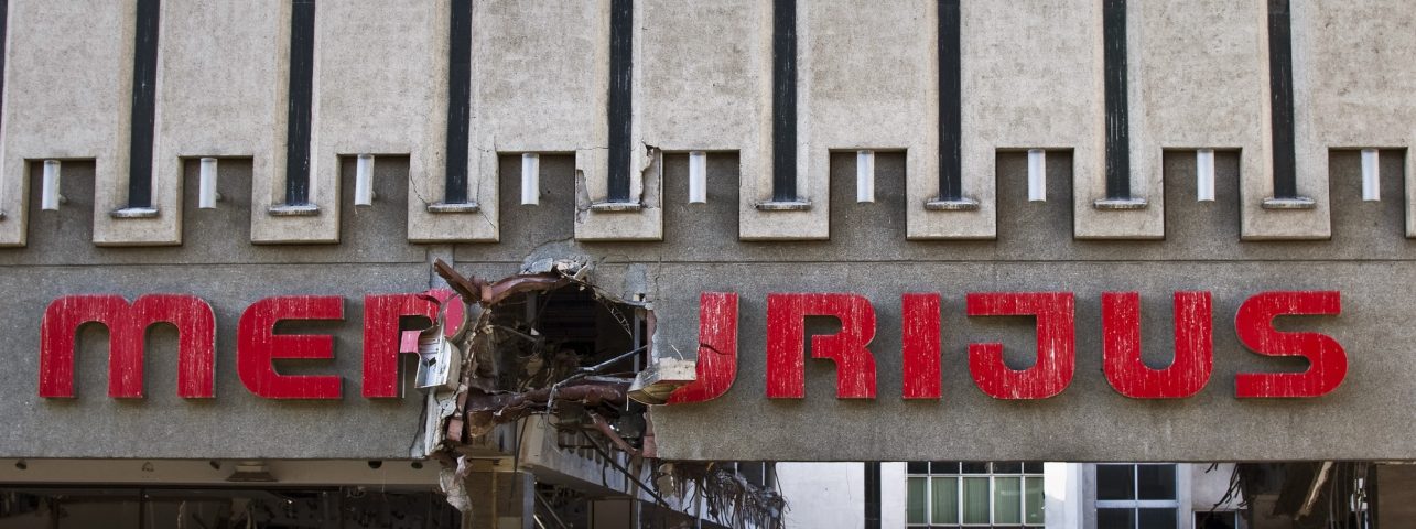
Photography is captured memories that last forever. For example, one of the photographs made by the hero of this article that had stuck in his memory shows the legendary dilapidated Merkurijus. In 2009 this image seemed ordinary to most people, and today, its significance for the city is infinite. There is no shopping centre anymore, but now it reminds the public of the decades-long development of Kaunas. Andrius Aleksandravičius has been documenting it every day for the last twelve years. When going on his daily walks and searches for new places, he always takes a drone with him to capture the most picturesque routes in Kaunas.
We started the conversation by talking about the rules of photographing that prevail in Andrius’ routine. “I use the drone only during sunrise or sunset. At first glance, it all seems very simple, but in the summer, the sun starts to rise only a few minutes before 4 am, so getting up is not that easy. Back in the day, I used to sleep through this time, but now I am glad that a few years ago, I started waking up with the sun. Apparently, I got used to this routine. Of course, sometimes it is difficult to remain awake until sunset, but the afternoon nap helps.” For Andrius, weather forecasts are an essential part of the photographic process. For example, the first snow completely changes the image of the city, and then he often manages to make the most beautiful shots.
For those interested in aerial photography, the photographer recommends checking some very important news. Since the beginning of this year, a new regulation has entered into force in the EU, “In order to use a drone that is heavier than 250 grams (the heavier the drone, the more requirements there are) and has a camera, the owner has to register it in a common system.” In Lithuania, the Transport Competence Agency is responsible for this.
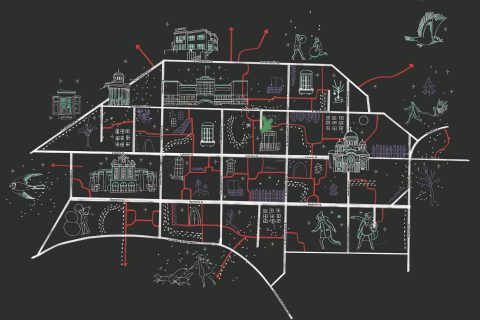
And now back to the routes. First, I didn’t hesitate to ask about a few places that were relevant to me. According to the interlocutor, the route from which the towers of Kaunas Old Town can best be seen on foot would be called Old Town – Aleksotas Observation Deck. After starting the trip in the Old Town, you should gradually walk towards the Aleksotas observation deck (it is recommended to take the stairs), stop for a moment and see the panorama, and then continue walking on the Amerikos Lietuvių Street until you reach the stairs of the Garliava Trail. After climbing down, you will see a completely different panorama of the city.
The Nemunas and the Nevėžis confluence is for those who miss silence and a breathtaking landscape. And not only the main trail, at the end of which the rivers meet, but also many small paths near the Nemunas. Andrius recommended starting the route from Lampėdžiai forest. And now it’s time for the carefully selected routes of the photographer, who also provided the illustrations.
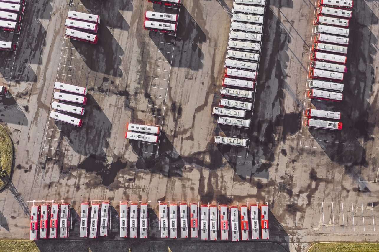
Old Town – Marvelė – Č. Radzinauskas Bridge – Kulautuvos Street – Bus Park – Brastos Street – Vilijampolė Bridge – Old Town
The 10 km long route may not be very popular, but it is very interesting. Although each area is very different from the other, I have no doubt that the view of Santaka seen from the side of the Nemunas, the landscape opening from the Česlovas Radzinauskas bridge, and the panoramic Vilijampolė district will catch the eye of every traveller. I’d like to call it a village in the city. Let’s not forget the Inland Waterways Authority’s boats located on the shore or the red busses lined up in the park – these are some unusual images.
Laisvės Avenue – Žaliakalnis’ wooden houses – Ąžuolynas – Laisvės Avenue
You can experience this route in different ways – you can climb the stairs of Pompėja, Kaukas or Vytautas Park and immerse yourself in the search for the most interesting wooden house or just wander the small streets of Žaliakalnis. Each time I go there, I try to take different paths. How many beautiful hues one can see on Gėlių and Minties Circle streets! The journey continues by walking around Ąžuolynas and later descending the stairs of Vincas Mykolaitis-Putinas.

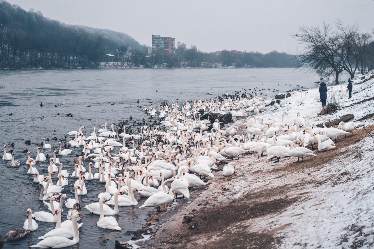
Laisvės Avenue – Daukanto Street – Embankment of Nemunas – Žemieji Šančiai – Panemunė – Studentų miestelis (KTU campus) – Ąžuolynas – Laisvės Avenue
An almost 3-hour long route is all about getting to know Žemieji Šančiai. Main sights: wooden houses, modern houses, swans that gather next to one of the blocks of flats located near the Nemunas in winter, Panemunė pinewood, Trijų Mergelių Bridge, KTU campus, and, of course, Ąžuolynas.
Laisvės Avenue – Daukanto Street – Embankment of Nemunas – Juozapavičiaus Avenue – Drobės Street – Švenčionių Street – Prancūzų Street – Kaunas Railway Station
Another great route for those who want to get acquainted with Žemieji Šančiai, located on the other side of A. Juozapavičius Avenue, and ascend to a special place located in Aukštieji Šančiai, the Švenčionių Street, also known as Mother-in-law’s tongue. After that, I would recommend wandering around Prancūzų Street and later, when on Lentvario Street, descend to the railway station, where you will experience a completely different view than the one seen from Tunelio Street.

Laisvės Avenue – H. and O.Minkovskių Street – Aleksotas Bridge – Old Town
I would venture to say that this is the route of the future. Some places are still not comfortable for walking due to narrow or non-existent sidewalks, but this route opens up a completely different Kaunas. The Žalgiris Arena from the other side of the Nemunas, the buildings of Kauno Grūdai, and the railway of amazing beauty surrounded by trees next to the old Jewish cemetery of Aleksotas. In fact, I think that with the emergence of new bridges from Nemunas Island, this part of Kaunas will recover, and we will be able to get there much easier.

Laisvės Avenue – Ramybės Park – Railway Station – E. Fryko Street – Vytautas Park – Small Ąžuolynas – Kauko Alley – A. Mickevičiaus Street – Owl Hill – Old Town
I really like this route because it offers many different panoramas of Kaunas. At the end of Fryko Street, you can see the railway station from above and from Vytautas Park, a part of Laisvės Avenue, and St. Michael the Archangel’s Church. The Owl Hill offers a panoramic view of both the new and the old town and, on the other side, far away in the distance, view of Šilainiai. And in the end, particularly fun descent to the Old Town via quiet Benediktinių street.

Laisvės Avenue – Vienybės Square – Aušros Path – Žemaičių Street – P. Kalpoko Street – Embankment of Neris – Old Town
This route could be called “How to get from Laisvės Alley to the Old Town via a detour.” The recently renovated Vienybės Square, a beautiful Aušros Path, and the nearby buildings are pleasing to the eye. After that, you can go down Kalpoko street to the embankment of the Neris.

Old Town – Kleboniškis
This route, located along the Neris, leads all the way to Kleboniškis. You can start the journey at the end of Jonava Street and choose a route of the desired length. If you have time, go all the way to Naujasodis, which is on the opposite side of Kleboniškis Forest.

Dainava – Kalniečiai
A short walk to get acquainted with Kaunas parks: the newly arranged Draugystės and Kalniečių parks, Daiva Park, and a very beautiful Čečėnijos Square.